By Carlos Gonzalez, general manager at geospatial technology provider 3D Laser Mapping discusses the importance of detecting a change in the mining sector. Implementing a safety management system in a high-risk environment such as a mine is critical to keeping workplace incidents to a minimum. But as any management team knows, providing a safe and hazard-free workplace can often impact on the productivity and efficiency of operations.
With hazard management plans and other procedures taking up valuable time and resources, can new technology be leveraged to automate some of the most time-consuming processes, and potentially take the extractives industries closer to ‘zero-harm’? Here, Carlos Gonzalez, general manager at geospatial technology provider 3D Laser Mapping, explores the options.
Early adopters of any technology stand to benefit greatly in terms of operational advantages over the competition but, in industries such as mining, there has been a multitude of barriers preventing digital change. Accessibility issues and difficult environmental conditions often mean that technology which is tried and tested in other heavy industrial sectors simply won’t work in mines. As a result, mine operators have had to rely on age-old practices when the rest of the industrial world has advanced. It may be some years before the ‘connected mine’ is commonplace, yet when it comes to detecting hazards, there are many accessible technologies available which have the potential to revolutionise worker safety.
Laser scanning systems are commonly used for producing digital terrain models and topographical maps of environments to assist with planning tasks. In other sectors, LiDAR is seeing rapid adoption for purposes such as building information modelling (BIM), asset management and infrastructure planning – all tasks which rely on accurate measurements for the success of a project.
Early warning systems
In any hazardous environment, it’s often after an incident that lessons are learnt, and mining is one such industry that has had to learn the hard way. One of the most feared events in any mining environment is a landslide. From the Nambija disaster in Ecuador to the tragic event in Aberfan, Wales – thousands of lives have been lost where mining activities have taken place.
When incidents result in loss of life or injury, mine operators must act. Slope stability monitoring is now commonplace in most mines in the developed world. The Bingham Canyon landslide is just one example of where an early warning system saved countless lives when 65-70 million cubic metres of dirt and rock collapsed down the side of the pit. The warning system deployed here consisted of three interferometric radar systems that were used to scan the pit wall at four-minute intervals. This allowed geotechnical engineers to identify progressive movement over the period of a few days prior to the eventual failure, giving plenty of time to evacuate workers prior to the collapse. Thankfully, no one was harmed in the largest non-volcanic landslide in US history, all thanks to the early warning system.
READ RELATED
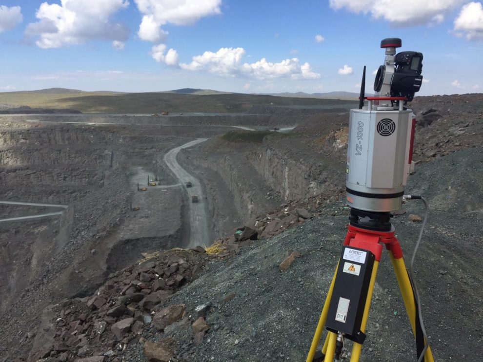
Another method of monitoring slope stability and rockfall events is laser scanning or ‘LiDAR’ mapping. LiDAR (Light Detection and Ranging) is an established technology that has been used for mine planning and geotechnical surveys for some years. Using the pulsed light from a laser, LiDAR systems generate a 3D map of the target area that can accurately represent surface features down to millimetre level. It’s this level of detail that makes them ideal for purposes such as monitoring slopes, where detecting small movements is critical when it comes to identifying an impending slope failure.

As part of the development process for SITEMONITOR +SLOPES, the research team at 3D Laser Mapping worked with both mine operators and teams of geologists to develop a solution that tackled the issues faced when trying to identify slope instability, without adversely affecting the efficiency of operations. +SLOPES uses time-series laser scans carried out by fixed scanners, with each scan then matched against the previous, to identify the change. Any change outside of set parameters sends an alert to both remote and onsite teams to warn of a potential threat, allowing time to investigate or take immediate action.
It isn’t just pit walls and mine slope stability that pose a risk to workers, as tips and stockpiles can also be at risk of collapse on a site. Waste dumps are a critical issue for mine safety where large amounts of loose materials are amassed prior to revegetation. By using the same type of technology, it is possible to map and monitor both the stability and quantity of materials being dumped so that operators and site workers can actively manage the safety of waste sites whilst also keeping an eye on the quantity of waste being disposed of.
Intelligent inventory management
Intelligent inventory management is another example of where technology is helping mining operations to drastically improve operational efficiency, whilst also realising benefits in onsite safety. Automated stockpile measurements prevent the need to expose workers to high traffic areas such as stockyards, whilst also providing management teams with up-to-date information on stock levels without the need for manual calculations. From production control and forecasting to inventory and audits, being able to actively monitor stockyards remotely can help to streamline efficiencies at the touch of a button.
Thanks to advancements in laser scanning technology, LiDAR systems are now more accessible for many businesses. Previously, laser scanners were prohibitively expensive which meant that the cost savings would never outweigh the capital investment for applications such as inventory management. Now, smaller systems are available which can be deployed to give a 360° vantage point across even a large-scale operation to automatically calculate volumetric change, which can be accurate down to millimetres. The resulting data can be automatically reconciled to show mined volumes that can then help to assess the efficiency of mining methods as well as the productivity of contractors employed on site.
Using LiDAR, automated stockpile measurements alleviate the need for stockyards to be manually monitored, thus removing the risk to workers previously tasked with inventory management and improvements to safety and efficiency.
Remote measurements
Another application where LiDAR can help to streamline processes is found in the application of shotcrete. Traditional methods of shotcrete application rely on operatives manually measuring the applied depths using probes or stamps. Using a spray rig mounted laser scanner and specially designed software, it is now possible to remotely measure the surface change in real-time.
Automated change detection systems such as PROCESSMONITOR LIVE use LiDAR data to actively visualise the surface at each stage of the spray concrete application process. The shotcrete operator carries out a scan remotely and from the safety of the shotcrete rig, feeding back colour-coded imagery that shows areas which have been over, or under-sprayed. Not only does this keep the shotcrete operator out of harm’s way, it also helps to cut wastage from over-spray at the same time as calculating that the right amount of shotcrete has been applied to ensure structural stability.
The same technology can also be used for accurate tunnel profiling tasks – something that is used to require complex surveys, ensuring excavation works are being carried out according to plans.
Integrated mine-wide safety management systems
A mine is a busy place, with the surroundings changing every second. When it comes to building an accurate situational picture in a mining environment, you would need hundreds of cameras or thousands of pairs of eyes to be able to monitor everything that was going on. Laser scanning produces huge datasets that can be used for many different purposes. Some LiDAR systems can capture around one million measurements per second, but it’s the interpretation of the data that holds the key to tangible business improvements.
Although designed to answer different challenges and act independently, modular scanner and software packages such as SITEMONITOR LIVE can now be integrated into a single interface to act as an integrated safety management system – passively monitoring multiple aspects of a mine’s structural safety, alerting operators when things go awry. This goes a long way towards automating hazard monitoring and alleviating the burden on those responsible for site safety day-to-day.
The benefits of LiDAR in a mining setting are numerous. Thanks to the sheer scale of data captured, it is possible to gain deeper insights into the productivity of operations on an ongoing basis. Recent advances in processing software also mean that data is available on-demand, without having to wait hours for office-based teams to process and interpret data streams. Put simply, this level of instantaneous intelligence can be the difference between life and death.
Read more Mining Safety News


Add Comment