If you’re about to commence a large mining infrastructure project or want to assess a current structure or area before building or expanding, you’ve likely started researching into mining surveying options. Thanks to advances in technology, HD surveying is becoming one of the most well-known and used survey methods in mining today.
So, what is high definition surveying, what benefits does it have over traditional methods and how can these benefits be transferred to you, the client.
What Is High Definition Surveying (HDS)?
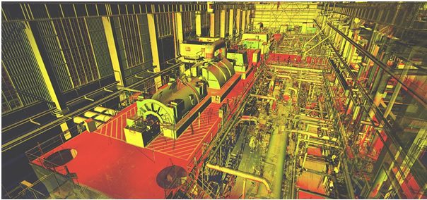
High definition surveying is the process of collecting complete, accurate and detailed as-built data of an area or structure. Using a stationary 3D laser scanner, millions of narrow, eye-safe beams are sent out in all directions to accurately map out the area in a matter of minutes. These scanners are incredibly accurate and will measure these points to provide XYZ values.
When surveying longer distances for projects such as pipeline, electrical, rail and road infrastructure, there is also the option of mobile HD surveying. This form of surveying is usually conducted using a road vehicle or unmanned aerial vehicle (UAV drones).
The Benefits of HD Surveying
High definition surveying provides a myriad of innovative benefits compared to traditional surveying methods. As the survey can be completed quickly and is safe even with workers present, it will cause minimal to no disruption to daily operations.
HD surveying also:
· Decreases Field Time
As HD surveying requires less manpower and can be completed quicker than traditional methods, it usually results in cost savings. These savings are usually passed down to the client who requested the work, reducing their overall project costs.
· Increases the Visibility and Overall Understanding of The Project
HD surveying produces an incredible level of visuals which gives a larger and more detailed picture of the project. This can then be transferred to an AutoCAD or BIM system to help produce a better understanding of all aspects of the project.
· Improves Project Monitoring
Firstly, high definition surveying can be used to document the existing conditions of your project, which you can then compare to previous conditions. Surveying can subsequently be used throughout your project to help you plan for further expansion, infrastructure improvements and changes. Finally, once the project is complete, you can conduct a final survey to gather data to be referred to during future expansion, maintenance and monitoring.
· Helps Identify Areas Requiring Maintenance
As high-quality imaging is produced by HD surveying, you can run condition and damage assessments of your site infrastructure and structures. This will help to identify areas which require attention prior to otherwise being known. Fixing issues quickly and efficiently will reduce downtime and boost productivity.
· Provides A Reduction in Health & Safety Risks
As mentioned, HD surveying requires far less manpower and time on site. This reduces health and safety risks dramatically compared to traditional methods.
So, How Does This Benefit You?
By entrusting a HD surveying specialist in the gathering of data for your project, you will reap a range of benefits. One of the biggest benefits is the likely decrease in overall project costs due to improved efficiency and innovative technology. Using HDS to survey your project or area will also:
- Minimise operational downtime
- Give you access to highly relevant and accurate data
- Reduce site visits by surveyors, causing less disruption
- Improve information management throughout a project
- Mitigate the risks
- Allow for more accurate future planning
Author Bio
This article is written by Alex Hamilton, on behalf of Veris – High definition surveying specialists operating a fleet of 3D laser scanners. You can catch Alex on Google+.


Add Comment