Ex-Tropical cyclone Imogen is expected to create a range of challenging conditions for miners in the next few days with high rainfall activity over the mining state of Queensland.
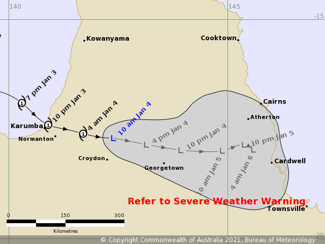
The Bureau of Meteorology has advised that “Ex-Tropical cyclone Imogen has weakened to a tropical low but remains a dangerous system with widespread flooding rainfall expected over northern Queensland.”
It confirmed today that “tropical cyclone Imogen has now weakened into a tropical low. The low is expected to continue moving east-southeastwards in the short term, taking it further inland today. Longer-term, the system is expected to track more slowly to the southeast towards the North Tropical and Herbert-Lower Burdekin coasts.”
HEAVY RAINFALL which may lead to FLASH FLOODING is continuing near ex-Imogen and is expected to develop throughout the remainder of the warning area between Wujal Wujal and Townsville later today. This HEAVY RAINFALL will extend southward to about Bowen during Tuesday.
Six hourly rainfall totals between 150mm to 200mm are likely. Periods of localised INTENSE RAINFALL leading to LIFE-THREATENING FLASH FLOODING are also possible, with six-hourly totals of 300mm possible about the coast and ranges.
Mine sites across the northern region of Australia have remained vigilant with the Rio Tinto Weipa Operation reportedly affected from minor localised flooding. Past wet weather incidents at mine sites has seen a range of haul truck collisions and collapse of a workshop facility
Many roads across the North of Queensland remain closed including the Burke Developmental Road, Kennedy Developmental Road, Gulf Developmental Road, Gregory Developmental Road plus other. Further information is available at the Road Condition Report Website Queensland
Flood warnings are in place along the coast, for all rivers between Cooktown, Cairns and Townsville.
Tropical #CycloneImogen‘s structure has changed, transitioning the system to a tropical low. Despite the name change, the rainfall is going to increase with widespread heavy rain & flooding expected. Damaging winds still possible with storms in the area. https://t.co/PXWp1ezyAK pic.twitter.com/6zH2H9Db2I
— Bureau of Meteorology, Queensland (@BOM_Qld) January 4, 2021
The Bureau of Meteorology has also issued a season outlook this week that points to:
- December to February rainfall is likely to be above average across most of Australia, except the west coast of Tasmania.
- Average daytime temperatures during December to February are likely to be above the long-term average across parts of the south-east; also far-west and north-east coastal parts.
- Average night-time temperatures from December to February are very likely (>80% chance) to be above the long-term average across almost all of Australia.
- La Niña is underway in the tropical Pacific. La Niña typically increases the likelihood of above-average rainfall across much of Australia during spring and early summer.
- A positive Southern Annular Mode (SAM) may also enhance rainfall in the east over the coming month.
You can keep up to date with the latest in movements of Tropical Cyclone Imogen from the Bureau of Meteorology here
Read more Mining Safety News


Add Comment